With Coast to Coast tucked away in the memory bank, focus shifted towards the Kaikoura Adventure race planning. This particular mission was carried under covert circumstances as it was about 6 weeks before the race, hence why I’m only writing about it now. It was a really cool mission though so I thought it would be nice to document it.
Friday night myself, Tim, Aaron and Matt headed north out of town to Kaikoura. Tim and Myself held a navigation training session in town while Aaron and Matt headed up to the Kennedy’s farm. They went on a hunt while we spent the evening teaching the basics.
They were successful and the training session went well but it was a late night, so our early morning start happened before 9am but not by much. We started at the Cloudy Range woodshed after calling in briefly at the farm house for a brief chat with the farmer (Also Tim needed a drink bottle…). With Aaron there is never much time to flaff around so the pack up was efficient and we were under way navigating out the gate. With quite a bit of navigation experience between us, especially at night there was a small amount of sympathy for those racers who were going to have to find their way out of here at night… just a little bit!
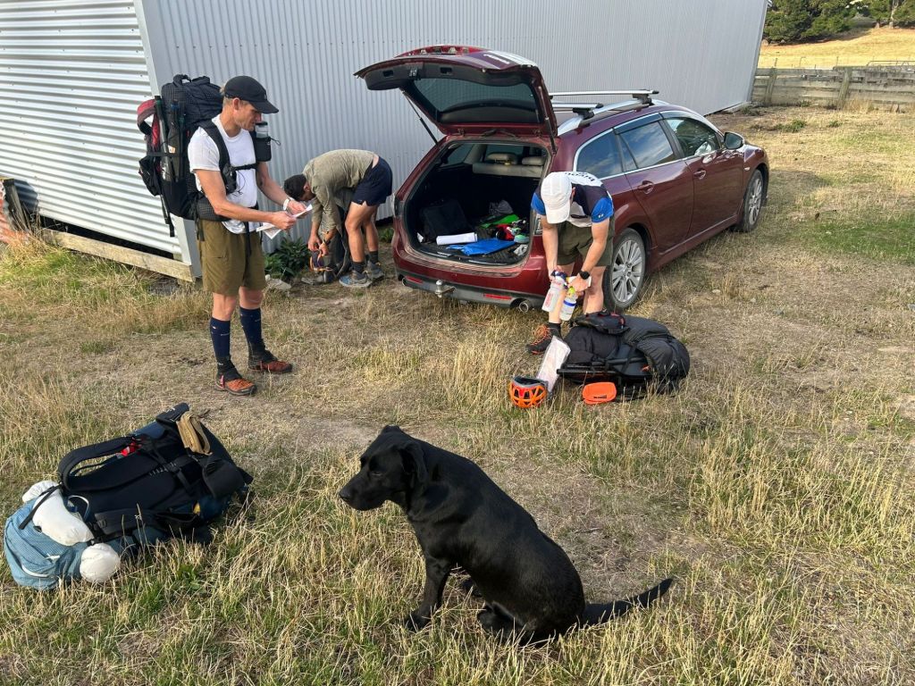
Getting ready under the watchful eye of the farmers dog
The first hour was quite a slog straight up a steep steep farm track. This one appeared to have been re-cut after the earthquakes had destroyed the old one. Another hour or so and it was time to leave the track. It was relatively straightforward, and we found some good animal tracks siddling a small hill before the steep scree riddled ridge appeared before us. We had a short stop in the saddle while we did some animal scoping, but nothing too long as we had quite a long trek and paddle ahead of us.


This climb to the top of the range was huge, quite steep and reasonably exposed. It was a grind but well worth it for the views in both directions to where we came and where we we were heading. The wind had picked up a bit on the tops so one minute it was freezing cold and the next boiling hot. Time for a quick lunch stop then down the otherside into the Clarence river valley.
The descent was steep, dry and scratchy. We picked our way through most of it easily, until right down near the bottom where there was some thick Matagouri to negotiate. We again discussed how glad we were to be here in the daylight and felt for those doing the race which would likely end up here in the dark!


Once at the river bed in the hot dry afternoon Matt and Aaron went for a swim to cool off. Even at close to 30 degrees C, it was not going to be warm enough for me especially with a 3 hour paddle areas of us!
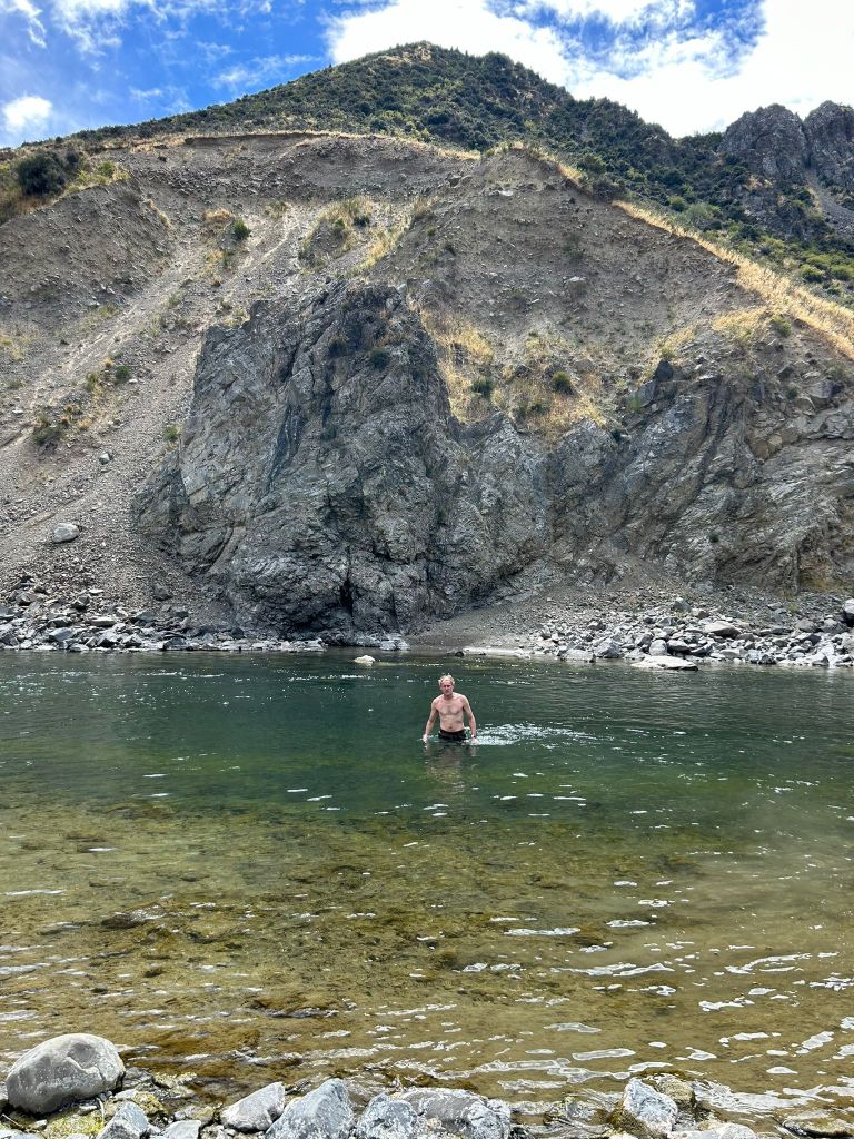
Swim time!
Rafts unpacked and inflated we began the paddle down stream. The first couple of rapids resulted in enough splashing to cool me down, so happy I didn’t go swimming beforehand!
There was only one or two really exciting rapids to negotiate, and thankfully not even that much pushing of the shallow gravel banks in places. Our get out point at Palmer Hut turned up just in time as it we were starting to run out of daylight. Plan A was to head to Palmer Biv about 6km up the Palmer Stream, however Palmer Hut was looking quite enticing sitting there above the Clarence, so we dropped in for a visit.
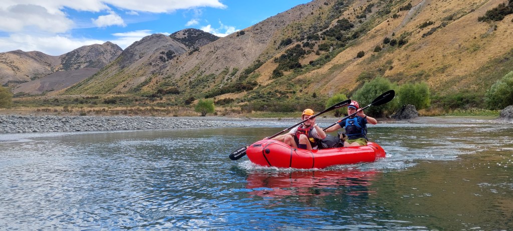
All calm on the Clarence
We were not really expecting to see anyone as the fire danger was so high the blind saddle road (generally restricted access anyway) was not letting anyone in. So we were a little supprised to come across a couple in a 4WD that were parled up there. They had come in before the road was closed and looked quite at home. So we decided to stick with plan a. We did a quick pack down and repack while being a bit coy about what we were doing… didn’t want anyone to catch wind of the course!
Back on our feet, we made some good progress as the river bed was really nice going, quite flat evenly distributed gravel. The location of Palmer Biv has a bit of a reputation as difficult to locate, so we kept our wits about us and contact with the map. At one point we had to take a turn up a side gulley that did not at all look like the correct way to go, then there was a small waterfall to negotiate. Right about where we thought the biv should be, we found it tucked away in some Matagouri just up a bit from the river. Nice little biv for two, so Matt and Aaron went for the tenting option. It was a cool little spot for an overnight stop for us…but probably not the racers in a couple of weeks time.


We broke camp just before 8am, heading up towards the saddle and a little bit into the unknown. This was the section we knew the least about. There was once an old pack track going up the True left of the valley, however we were on the right and the ridge travel looked more open and more enticing. We stuck with it.
At one point we did venture on a bit of a siddle to try to avoid some climb, but this took us into some quite sketchy scree slopes and we reasonably quickly redirected our efforts to the ridge. Progress was relatively good, only a little bit slow finding a good way to get to Palmer Saddle.

Looking towards the Clarence River from Palmer Saddle
At the saddle, and now the crux of the mission. We got onto the remains of the packtrack quite quickly, but it wasn’t a very visual track, quite overgrown with flax and tussocks and Matagouri. When the track ran out then it was down to us to pick the route. I was keen for the up and over bush bash, but Aaron was off down this gorgey little stream with a couple of small steps to climb down and around. Almost full immersion in a few places too! It was quite fun, but 800m of travel took close to 30mins and then we were faced with a waterfall, just too far to jump or climb down. We backtracked to a point where we were able to climb out amazingly close to a well worn animal trail. We followed that down quite a steep spur which looked like it was going to end up in a bluff, but animals always find a way down to water and it zigzaged down to the bottom where there was an old waratah which obviously designated it was the start of an old trail. Looking back up the valley we could see that that small waterfall we were stopped by actually lead into another series of waterfalls and culminated in a decent sized waterfall around 60m maybe?
Glad to be down in the riverbed, we made quick time on the side banks following animal tracks. As we made progress down the creek quickly got channelised and we walked into a bit of a trap. Backtracking about 100m we found a good place to cross and we were away again. This proved to be a bit of a critical move for several teams who got disoriented here in the night…
About midway down the Conway, we reached another critical decision point. There was a farm track going up probably close to 1000m or continue on the riverbed. Now the Intel we had told us the riverbed was good going as the earthquakes had washed down a whole bunch of gravel and smoothed it out. We knew what the farm track would be like, so opted for the fast option with a little bit of risk.
The risk paid off as from that point onwards progress was really good. We were going to be on target to get out by 3pm-ish. The weather up until this point had held out ok, but you could feel there was some threat of rain, and it got a bit cool too. After I took a little frustrating tumble in the river which required help to get up from, we needed to have a little lunch and warm clothes break.
This made all the difference, and another hour or so of bashing the gravels we reached the end of the gorge bit of the Conway. The gravel flats had a bunch of blackberries which soaked up quite a bit of our time as we feasted on them!
This last little trick to getting back into the farm to complete the loop required some superior nose following from Tim to get through the blackberry patch, then one final slogg up the hill to the farm house and the car. Mission complete!


Leave a comment