Since the arrival of my packraft I’ve been scouring the topo maps for cool places to take it, looking for something do-able for my ability but also something a little bit different. I spotted the East Branch of the Poulter one day while looking into the main Poulter River and the MacArthur Gorge looked pretty interesting and definitely worth investigating further. A quick search of the internet found no information on paddling conditions, or even any evidence that anyone had tried… so maybe it was worth a try. Linking it altogether and making a loop out of it was the hard part and I wasn’t too keen on just some out and back mission! Then all of a sudden it all clicked in my head and came together to make a pretty nice little loop, just short enough to fit into a weekend! Tim was also excited by the prospect of exploring new territory and with the weather forecast not looking fantastic, it wasn’t until we made a last minute call at about 4:30pm on Friday afternoon that the wheels were set in motion.
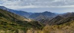
Saturday Morning, we hit the road with the obligatory Sheffield Pie Shop stop, and eventually crossed the very low looking Waimakariri River at Mt White Bridge. Doubt about whether there was going to be enough water to paddle started to creep into our minds. Rain looked like it was on its way and worst case scenario is we could just take big red for a big long walk, so we went for it. We left the car at Andrews Shelter and hit the track up to Casey Saddle, the walk was a lot steeper than I remember, but we made good progress heading into the worsening looking weather. This was about the first time ever I was actually hoping for the rain to come while on a trip!

On the way up to Casey Saddle
As we crossed over Casey Saddle we passed the only set of people we were to come across the weekend. A lonely trip out in the mountains! Once over the saddle it wasn’t long before he reached the site of the former Casey Hut. It was a little bit sad to see nothing in its place as it is the perfect spot for a Hut of all the places in the Valley. Luckily for me the toilet was still there though! It was now late in the afternoon, and the clouds gathering made it feel a lot colder and ominous than it really was. We headed up the Valley and then crossed over to head up Fenwick Stream. There was a recently flagged trail right at the entrance of the bush which we followed for a while, but then Tim decided that we would be faster to walk up the stream bed. Prospects of paddling were not looking good with not much water in the stream at all!
Closer to the top of the stream bed was a tight little gorge we walked through which was pretty cool, although I think the main trail actually went up the true right in the bush here, as we had to cut up a steep little gut to get back on track from inside the gorge. The going along the trail to Ranger Bivouac was great, there had been some very recent trimming work and periodic dumps of pest control traps, yet to be unwrapped and placed. The going was pretty tough lugging the big heavy packraft, but well before dark and dinner time we reached Ranger Biv. The bivy was well placed, tucked away nicely on the edge of the bushline next to a tarn hidden away from the high winds!
We had a cold night in the two bunk bivy, luckily there was a fire which we got roaring away. Unfortunately the fire needed constant attention so as we lay down to sleep it cooled down very quickly. Tim in all his packing wisdom forgot his sleeping bag…. so luckily for him I had a survival bag he borrowed while I froze in my lightweight sleeping bag on the broken sacking bunk by the window. At about 2am I gave up trying to sleep, and rushed outside and got some more fuel for the fire. We got it roaring again, and produced just enough warm to allow me to get back to sleep for a few more hours before daylight.


Even after a rough sleep we didn’t get going super early, well I don’t think it was early, as overnight daylight saving had happened so we really had no idea whether it was 7 or 8am. From the hut we headed up to the tops, and quickly encountered the wind. It was cold and vicious wind and didn’t really let up, there had been rain overnight, but not much since daylight. At around 1500m we hit the snowline, which meant some terrain was easier and some harder to traverse. Once on the tops we travelled quickly to reduce the time exposed to the wind. The visibility came and went, but seemed to be pretty constant above the 1600m mark. We made the choice to deviate from our plan of following the tops to the spur we wanted to come down, to dropping to the wind shaded side and siddled through a few basins. There were a number of snow slopes that we needed to cross but they were a little icy and quite steep to cross safely, without ice axes… so out came the paddles! Not ideal, but a temporary solution.


Eventually after many ups and downs through the basins, we reached the spur and headed down in the full force of the wind towards the Cox river. The terrain got pretty steep at the bushline and Tim who had the map realised we had actually come down the spur to the left of where he was intending. We were not too keen on heading back and by the looks of the terrain and on the map we thought we could probably get down ok. Sure enough there was some really good deer trails to follow. Had you put an orange triangle on it you would have sworn someone had a cut a track there! We dropped down through the bush, did a little bit of bush navigation to get through a flatter section and hit the Cox River bed.


The river was looking pretty low, but we thought we would give it a go anyway with the Packraft. As we inflated it, just enough rain started to fall to wet the rocks, a little too late really to help us out there. The first few rapids required a little bit of bottom dragging and climbing out. Then after about 2km were reached the entrance to the lower Cox Gorge.
The lower Cox Gorge, is a small section of about 1km near to Bull Creek hut. I have no idea if anyone had paddled in here before, and it’s not officially named as a gorge at all but herein after I have referred to it as such! As we entered the gorge we passed through into the unknown. There were a couple of rapids in there that needed some scouting and it was mostly grade II+ to III. We negotiated all but two of the rapids, portaging the tricker lines due to our remote location and lack of speedy contact with the outside world if anything went too wrong. It was a really quite beautiful little gorge, well worth exploring and at the levels we were paddling only just doable.

In the lower Cox Gorge
Once out of the Gorge, Bull Creek came into the main flow and the river dropped away quickly in the direction of the Mounds of Misery. Roughly 2kms later the River bends, and turns into the East Branch of the Poulter and the MacArthur Gorge where it cuts through to the main Poulter valley. In the East Branch there was a number of bluff rapids and again some quickly descending wave train type rapids and of course many rock gardens to negotiate. There was maybe two rapids in there which we chose to scout, just because we were unsure of what the river was actually doing, but everything in there was a doable grade II (Waimak Esk Stage height 0.2, Waimak Otarama 55cumecs). It was a really fun gorge to paddle and I enjoyed it thoroughly.

The planned loop… not quite as executed. Red = Tramp, Blue =Packraft. We actually walked further along the tops to 1740m and got into the Cox river a little bit higher than shown approximately opposite Cochran Stream. Green was plan C.
Once out the other side and into the main Poulter things got better and better paddling wise. There was some really interesting Rock Gardens with goo fun wave trains. The body was now starting to get a little tired and stiff from sitting down in the front of a wet packraft for the last few hours and I was getting a bit “hangry”. At around 4pm we got off the water and joined the Poulter River track, right at the point where it splits and head back over Binser Saddle. We did a quick pack up as it was a little cool and quite windy, and as we got going again, the body started to warm up a bit. It was a fairly pleasant walk over the saddle and back to the car at Andrews Shelter, just before sunset, making for the perfect weekend loop. We couldn’t have asked for better really!


Leave a comment